drawing of Sea Island - Sea Island Heritage Society logo

Our Past is your Present!

We are a non-profit organization focused on promoting, preserving, and being a strong, active resource for all things of heritage value on Sea Island in Richmond, British Columbia. Join us to learn about the history of Sea Island and its residents, past and present.

Newsletter

Vancouver International Airport (YVR)

postcard of Vancouver International Airport in 1951

Postcard of Vancouver International Airport, 1951

About Sea Island

Richmond, British Columbia made flying history prior to the opening of what is now the Vancouver International Airport (YVR) on Sea Island with its first flight west of Winnipeg, Manitoba. On March 25, 1910, Charles K. Hamilton took his Curtiss pusher biplane for a short flight over the wide-open spaces of Lulu Island as 3,500 spectators watched from the Minoru racetrack in present day Brighouse. Many other records were made and broken at Minoru. By that time, Richmond’s first airport dubbed “Vancouver Air Port” was established on a 40-acre strip south of Alexandra Road on Lulu Island, just a mile from the Minoru racetrack (between present day No. 3 Rd and Garden City Road) before YVR was moved to its current location on Sea Island.

Vancouver Airport moves to Sea Island - 1931

You can blame the creation of YVR on the famous aviator Charles Lindbergh. In 1927, Charles Lindbergh turned up his nose at an invitation to include Vancouver in his North American tour to mark his epic New York to Paris flight because “there was no field fit to land on”.

In December 1928 the Joint Air Board and the Federal Government represented by Major McLaren decided to get the City of Vancouver to arrange for the acquisition of 200 acres on Sea Island to replace its original grass airstrip on Lulu Island.

In 1929, the City of Vancouver purchased 478.61 acres on Sea Island as the site for what is present-day YVR. The land was purchased from various farmers including the Erskines, Murphys, Cooneys and McDonalds to assemble the required acreage. The first sale of land was undertaken between James Erskine and the City of Vancouver for the purchase price of $600 per acre.

In 1930, the construction of the airport started. Richmond Council was required to upgrade the roads leading to the airport site and provide the water and sewer connections.

On July 22, 1931, when the Vancouver Civic Airport and Sea Plane Harbour officially opened, life on Sea Island as a rural paradise started to change tremendously. One of the major reason Sea Island was chosen as the site for the airport was because the island is flat compared to the rest of the Lower Mainland. The Vancouver Civic Airport opened in 1931. It is today’s Airport South or the South Terminal.

The airport was administered by special committees composed of Vancouver City Council members and the Airport Manager until WWII.

Commercial flights

In 1934, the Vancouver Civic Airport started commercial air transportation services. United Airlines began a trial service to Seattle. In 1937, the airport saw its first Montreal to Vancouver flight which took 17 hours and 35 minutes and the birth of Trans-Canada Air Lines (Air Canada) and Yukon Southern Transport (Canadian Pacific Airlines).

World War II and RCAF Station Sea Island – 1940s

The outbreak of World War II meant great changes at the airport. As the only established airbase on the West Coast available to the Canadian armed forces it became a defence zone operational base of the Royal Canadian Air Force (RCAF) known as RCAF Station Sea Island.

During WWII, the authority regarding Vancouver Airport was assumed by the Federal Government, with the special committee continuing to function in the daily operation of the airport.

In 1941, plans were underway to build Burkeville, a Sea Island community to house 300 families. This housing became a necessity with the establishment of the Boeing Aircraft factory at the airport. This meant the government expropriated more land. Farmland belonging to Ernest Cooney, James Erskine and Robert Boyd was expropriated and used to build Burkeville.

The Federal Government purchased more and more land for the airport expansion. In November 1942 the farms belonging to W.A. Hayward, James Williamson and Mr. McDonald were absorbed into the airport holdings and some roads were closed. The government also installed a chlorination plant close to the junction of Miller Road and Airport Road.

With the war effort, the idyllic pastoral landscape of Sea Island became a heated construction zone. Mud-coloured shacks and barracks were hastily thrown up to house the air force personnel while abandoned farmhouses waited for the wrecker’s ball to the clear the way for more building.

In 1947, the control of Vancouver Airport was returned to the City of Vancouver.

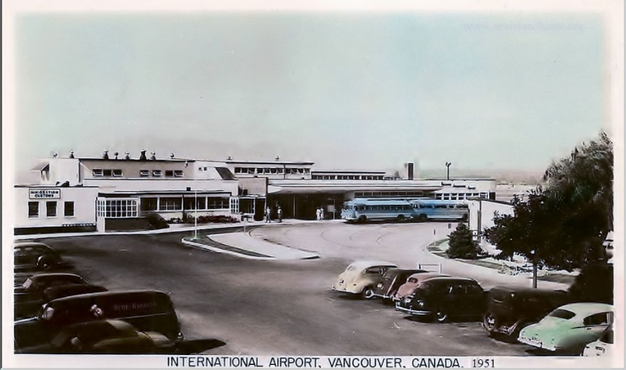
The airport continued to grow. It was renamed the Vancouver International Airport (YVR) in 1948.

In 1949, the administration of YVR was changed for the special committee method to the Vancouver Airport Board via by-law no. 3146. The Board consisted of five unpaid members functioning as the administrative body of YVR. That same year, the original YVR was destroyed in a fire. Work started on a new facility immediately. This new terminal opened in 1950.

Expansion of the Airport - 1950s

From 1890 to 1954 Sea Island was known for its dairies. In 1954, Frasea Farm owned by the Grauer family was sold due to the land appropriations for the Vancouver International Airport. The Grauer family also owned other farmland on Sea Island, which would be held in a legal dispute with the Federal Government for 30 years. The Frasea Farm was impressive with its large barns and dignified farmhouse. Although Frasea Farm was the largest dairying operation, there were many other dairies on Sea Island.

The late Gerald “Gerry” Bicknell said that in 1941 his family moved to Sea Island from Point Grey. His father, Mr. H. Percy Bicknell, was the manager of the Vancouver Cannery on Sea Island. The Federal Government expropriated the Bicknell’s Shannon Road property for airport expansion around 1950. The Bicknells moved to 198 McDonald Road on Sea Island. The Bicknell property was part of a small community at the southwest end of Sea Island, where the Acme Cannery and Vancouver Cannery, the Cork Mill and the Japanese Canadian community used to be. The Bicknells were neighbours to Doreen Braverman and her family.

In 1957, more land was purchased for what would become the very first jet-era aircraft hangar. This hangar now known as the BCIT Hangar, Building T-131 and the Britannia Hangar still stands at 5301 Airport Road South on Sea Island. It is recognized as a federal heritage building.

In 1958, the Bicknell family was further expropriated from their home at 198 McDonald Road. Gordon Bicknell, Gerry’s brother was also expropriated from his home at 503 Grauer Road, all for the expansion of YVR.

In 2000, Gerry Bicknell provided the Sea Island Heritage Society with a hand-drawn map of Sea Island showing the first airport in the 1950s, the canneries, farms and residents as he knew them when he lived on Sea Island. Gerry included a legend, indicating the location of the first airport (now the South Terminal) at number 12.

hand drawing of map of Sea Island by Gerry Bicknell

Hand-drawn map of Sea Island in the 1950s courtesy of Gerry Bicknell.

Map Legend
1 - Eburne Sawmill 16 - Cannery site 31 - Mr. & Mrs. Miller
2 - Marine Gas Station 17 - Indian Midden 32 - Clarence Hoggard farm
3 - Marpole Bridge 18 - Japanese Boatworks (Baba) 33 - Mike Murphy farm (best one to work for)
4 - Eburne Post Office 19 - Wharf 100' x 70'+ 34 - Radar Tower WWII
5 - Grauer Store 20 - Japanese Boatworks 35 - McDonald farm
6 - Clausen (sp?) Blacksmith 21 - Acme Cannery, 21(a) Thomas Goulding's Cork Mill 36 - Musqueam Indian Reserve
7 - Eburne Bridge 22 - Japanese Boatworks 37 - Tapp Road subdivision
8 - Community Hall 23 - Vancouver Cannery Donald Farm 38 - Ralph McDonald farm
9 - Burkeville 24 - Vancouver Cannery Store 39 - Duncan McDonald farm
10 - Sea Island School 25 - Marine Gas Dock 40 - McDonald Beach
11 - Dinsmore Island 26 - Japanese lived in this area 41 - Cora Brown subdvision
12 - Site of 1st airport 27 - Cannery Wharf 42 - Dick Laing farm
13 - Boeing site 28 - Cline Hoggard farm (both sides) 43 - Grauer farm
14 - Seaplane base 29 - Karl Hoggard farm 44 - Army Barracks WWII
15 - Terra Nova Cannery 30 - Poplar Tree Stand 45 - Dummy anti-aircraft gun (wood pole for barrel)

Vancouver sells YVR

In 1962, the City of Vancouver sold Vancouver International Airport (YVR) to the Ministry of Transport (Federal Government).

Expropriation of Cora Brown – 1966 to 1974

Following Word War II there was a great housing shortage and the Veterans Land Settlements subdivisions were established throughout Richmond and the Lower Mainland. This included the Cora Brown subdivision built on the northeast corner of Sea Island. Cora Brown was in existence for slightly less than 30 years.

In 1966, the Minister of Transport for the Federal Government announced that the Ministry of Transport would eventually take over the whole of Sea Island for the expansion of the Vancouver International Airport. Householders in the Cora Brown subdivision and Burkeville were pitched into a state of uncertainty. Around 1968, the Ministry of Transport and the Department of Public works began buying properties in the Cora Brown subdivision on a voluntary basis.

As everyone knew that there was no future in buying these houses, the homeowners were left without any viable alternatives and were forced to sell to the government. The Federal Government's vague policies and expansion intentions affected the whole community of Sea Island. In 1971, an agreement was drawn up between the Government and the remaining Cora Brown residents. The Government decided not to confirm this agreement and went ahead with the expropriation orders. By the end of 1974, all the houses had been purchased by the Government and the residents of this closeknit community were living elsewhere.

Although Burkeville was originally part of the wholesale expropriation of Sea Island, it escaped the airport expansion and remains a viable community, the only residential area on Sea Island.

Click any of the buttons below to read more about each subject.

On September 10, 1968, YVR opened a new terminal building, the Main Terminal Building (present-day YVR) to handle all domestic, United States and international flights. It was one of the few airports where aircraft could pull up to gates attached to the terminal and passengers could load and unload via a bridge.

In 1975, YVR was enhanced further with the opening of the 5,500-foot long 65 feet wide Arthur Laing Bridge over the north arm of the Fraser River.

On May 31, 1976, the Grauer store became a casualty of the expansion of YVR and related transportation system and closed its doors after much legal wrangling with the Federal Government over-compensation and expropriation. The store was demolished in 1980 along with other buildings in the locality effectively putting an end to the life of Eburne. The North Fraser Port Authority building now occupies the previous store site.

In preparation for the Vancouver World Fair (Expo 86), YVR received $32 million to modernize and prepare for the millions of expected visitors. During the 1990s, YVR became the fourth airport in Canada to be run by local, community-based, non-profit organizations.

YVR is located on land that is Musqueam traditional territory.

On June 21, 2017, YVR and the Musqueam Indian Band signed “The Musqueam Indian Band – YVR Airport Sustainability & Friendship Agreement. The 30-year agreement includes a number of items including the identification and protection of archeological resources and support for ongoing operations and long-term development at the airport.

On August 2, 2023, YVR suspended construction activities on the southern half of Sea Island, encompassing its South Airfield, following the discovery of what are believed to be Musqueam artifacts on the site as agreed in the Sustainability and Friendship Agreement. The Musqueam Indian Band was notified and the artifacts were sent to a certified archaeology and heritage lab for technical assessment.